
LiDAR Technology in Forestry and Taan Operations

Taan Forest has been using LiDAR technology since the first scan of our tenures in 2015. Over the course of the past decade, this practice has become the golden standard due to its ability to provide exceptional topographic survey data.

WHAT IS LIDAR? HOW DOES IT WORK?
LiDAR is an acronym for "light detection and ranging." Sometimes referred to as "laser scanning," this technology uses eye-safe laser beams to create a 3D representation of the surveyed environment.
A typical LiDAR sensor emits pulsed light waves into the surrounding environment. The pulses bounce off surrounding objects and return this information to the sensor. By measuring the length of time each pulse takes to return to the sensor, it calculates the distance the pulse travelled. The scanning process repeats millions of times per second, and in tandem with its satellite GPS functionality, can create an exact 3D map of the target environment.
Sometimes referred to as laser scanning, LiDAR is an acronym for "light detection and ranging."
LIDAR'S ROLE IN FORESTRY & FOREST STEWARDSHIP
There are two types of LiDAR systems based on their functionality: Airborne and Terrestrial. Installed on a helicopter, plane or drone, Airborne LiDAR has numerous invaluable applications in forestry and environmental stewardship - such as the following:
MICRO-TOPOGRAPHY & LAND CLASSIFICATION
Since LiDAR's laser pulses can penetrate forest canopy and vegetation and undergrowth, surface elevation can be precisely determined – even in dense or inaccessible terrain. The information collected can determine land allocations for forestry, habitat management, development, and more.

LiDAR data provides accurate ground slope and tree height information.

Taan Forest Engineers use LiDAR to do road projections, deflection lines, establish potential harvest boundaries to reduce cost and improve efficiency.
PRECISION FORESTRY: PLANNING, MAPPING & MANAGEMENT
LiDAR technology can measure vertical structures in the canopy, facilitating forest density calculations and potential block yields.
Scans can equally determine individual tree characteristics such as crown diameter, height, and tree health. Establishing the quality of a specific tree is advantageous for selective harvesting practices such as heli-logging. And without even stepping foot on the ground, it is now possible to determine specific terrain characteristics and soil type/quality for planning for planting and fertilizing.
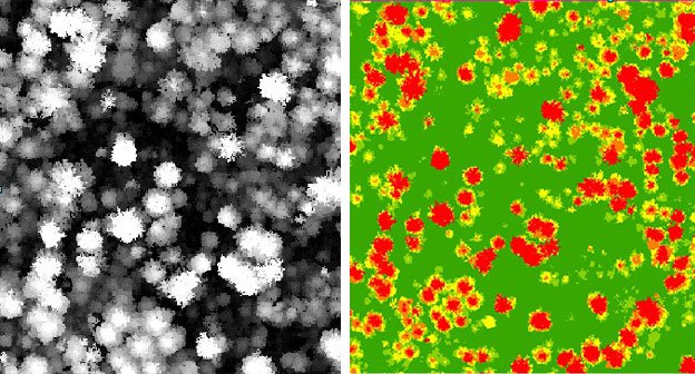
Individual trees can be identified from LiDAR. Heights can also be calculated and colour-coded by class to provide valuable information.
HARVEST ASSESSMENTS
To ensure harvesting allocation accuracy, comparing the expected forest outtake to the actual tree output is critical. Thanks to LiDAR technology, audits are executed with unparalleled speed and precision. Scan data can explain the cause of any discrepancy and monitors subsequently utilize the information to institute control measures.
ENVIRONMENTAL ECOLOGY ASSESSMENT & MODELING
LiDAR scanning has become a key component when conducting environmental assessments. Monitoring can identify areas at risk from human activity degradation and serves as a protection measure for sensitive areas. Biologists can also determine habitat suitability for specific animals and bird species by analyzing data on a forest's vertical cover. Amazingly, LiDAR can map pollutants and provide the data necessary to calculate a forest's carbon absorption capabilities. With this information, scientists can diagnose a region's tree health and develop strategies for improvement if indicated.

Improving Visual Objective Modeling – LiDAR-based 3d digital elevation model used to update visual inventory and accurately build models to show the impact of proposed forestry operations. RGB values are used to colour LiDAR point data to mimic trees.

Yakoun bridge on Port Main in a 100-year flood event – Note Port Main underwater.
LiDAR also provides improved ability for Flood Mapping modeling – watershed boundaries defined more accurately and hydrological recovery calculated using metrics derived from LiDAR.
FURTHER LIDAR BENEFITS
Employing this dynamic technology has resulted in improved efficiency for Taan Forest and has dramatically reduced engineering and surveying expenditures. The benefits of investing in LiDAR extend far beyond our organization, however. By contributing valuable data to other initiatives, various studies and projects further benefit the lands and people of Haida Gwaii.
The Council of the Haida Nation (CHN) uses Taan LiDAR data for its archeology program to identify sites of interest, such as potential hidden villages and raised beach sites. They also utilize the LiDAR to check proposed cut blocks against land features and streams, plus sensitive areas like flood plains, active fluvial units and steep terrain.
The Geological Survey of Canada uses our data for seismic and fault zone studies, as does the University of Washington.
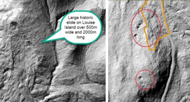
Historic Inventory Features, huge slide on Louise (left), changes in river paths, Skidegate roads built in WW2 etc. LiDAR data used for Karst inventory work (right).
Via the Canadian Coast Guard, the Federal Government applied the data we provided to position power lines for Alliford Bay's communication tower.
In association with The Haida Gwaii Management Council and the Haida Gwaii Data Sharing Group, the Provincial Government used Taan LiDAR to define tree heights for the Vegetation Resource Inventory and to improve the formal ecosystem modelling of Haida Gwaii.
The Villages of Daajing Giids Queen Charlotte and HlGaagilda Skidegaterelied on Taan's LiDAR to determine tsunami heights on land. As a result, you may notice that telephone poles in both communities are marked to indicate potential tsunami water heights.

Tsunami Warning Zone Using the accurate elevations from LiDAR safety zones were established and marked.

The University of British Columbia was granted data access to assist with a significant SGaahlan yellow cedar dieback research project.
Data was provided to a UBC research student for analysis as part of Martin Habitat Research.
Taan's LiDAR data has also been beneficial for Stads K'un Haida Gwaii Goshawk Habitat modeling. The tree height and crown information collected is used to compare where Stads K'un is currently, and identify potential habitat areas.